
Place Calculation Points
AGi32 provides the capability to provide RP-8-18 compliant grids on top of CAD backgrounds. This includes all of the relevant calculation grids such as Luminance, Illuminance, Veiling Luminance and associated quantities. This is done using the Add Calculation Points – Roadway command. Using this method, it is possible to stretch the length of the grid past the RP-8-18 typical section of roadway (one luminaire cycle). It is important to understand the ramifications of this flexibility.
Caveats:
- Beware that the IES observer is 83m back from each calculation point. The street should be straight enough that the observer positions are not outside the lane boundary.
- Adequate luminaire cycles must be considered both behind the grid start and after the grid conclusion.
- Typically, at least two cycles behind (toward observer)
- Typically, all luminaires in front of observer as these impact the calculation of veiling luminance.
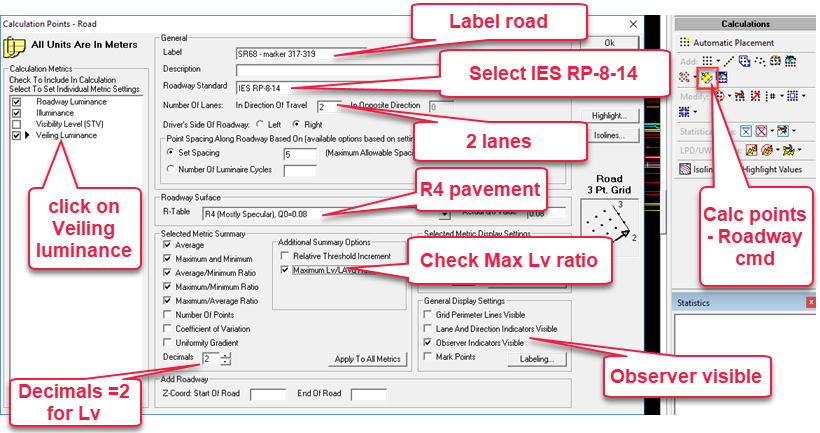
Place eastbound points (bottom lanes)
- Access Viewpoint “Markers 317-319” from the menu.
- Select the Add Calculation Points – Roadway command from the Calculations toolkit.
- Enter a Label for the street (this would be important for real projects). We used Eastbound Marker 316 - 319.
- Select roadway standard of ANSI-IES RP-8-18 Roadway.
- Enter number of lanes in direction of travel (2).
- Do not alter the defaults for Point Spacing...
- Select R4 pavement type.
- Click on Veiling Luminance in the left side menu of metrics, the options in the lower portion of the dialog will change to be relative to Lv.
- Check the Maximum Lv/Lavg Ratio.
- Set Decimals to 2 for Lv.
- Check Observer Indicators Visible (Should be enabled by default).
- Click OK to close the dialog and place the points as below.
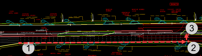
- Set the first point of the grid at the first pole location we set on the bottom of the street (left click).
- Drag the cursor to the second point as shown below (left click).
- For the third point move across the two lanes of traffic and left click again. You should have four rows of points, 2 per lane. See capture below.
 RESCUE
Open the file: RESCUE-Street-4.AGI

